Using AI to control energy for indoor agriculture
30 September 2024
Published online 4 May 2010
Scientists from 15 Mediterranean countries launched a large-scale scientific project to study the various problems affecting the region, and to advise policymakers on how to best address these issues.
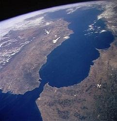
The People for Ecosystem Based Governance in Assessing Sustainable Development of Ocean and Coast (PEGASO) project, which had its official kick-off at a meeting on 12 April 2010 in Venice, Italy, will collect scientific data about the Mediterranean and Black Sea basins and coastal areas over the next 4 years. The data will be used to present specific action plans to policymakers in the 21 different countries that signed the Integral Coastal Zone Management (ICZM) protocol for the Mediterranean in January 2008. The protocol aims to preserve coastal regions as natural and cultural heritage sites.
"All the countries that have signed the ICZM protocol have committed themselves but know there are large obstacles they need to deal with. The idea [behind PEGASO] was to present a proposal to give them support," said Françoise Breton, who is the project coordinator.
The project will collect all the scientific data already available about the sea basins and coasts, and build upon them as needed. The data will then be checked, verified and added to a standardized database. "We have a very good team to correct the [collected] data and harmonize it in such a way that it can all be used together," added Breton.
The researchers will use a wide-ranging set of tools, such as remote sensing, spatial analysis and socio-economic assessments, to create a complete, detailed map of the Mediterranean.
"We need to know what is happening in each square kilometre of the sea. We already have the methodology and most of the information to do it. We want to map the sea at three levels of depth," explained Breton. The resulting map will have overlays of the different stressors. It will provide general information about the whole region, but also allow policymakers to zoom in and get specific information about a certain area or layer of the map.
The scientists are divided into working groups that will study different areas, such as the Moroccan Mediterranean coast, the Nile Delta in Egypt and the northern coast of Lebanon.
"The challenge of the proposed project is to streamline all the existing coastal initiatives to produce the best integrated assessment for the area, and design policies in accordance with the ICZM protocol," said Maria Snoussi, who is a professor at the University Mohammed V-Agdal, Morocco.
"Each area has its own indicators and conditions. So in Egypt, I can't apply the same ICZM plan that I would in Italy, for example," said Suzan Kholeif, who is the head of the Scientific Documentation and Media Unit in the National Institute of Oceanography and Fisheries (NIOF) in Egypt. "We must look at local factors such as the condition of the water and the coasts, biodiversity and agriculture."
The Mediterranean is integral to the economy of the countries surrounding it, especially those situated to its south. In Morocco, the coastal region is home to 60% of the population, with important industries and beach resorts. "However, due to diverse human pressures and poorly regulated development, many coastal areas are already experiencing acute environmental problems, such as coastal erosion, pollution and degradation of coastal wetlands," said Snoussi, who is also the national coordinator of PEGASO.
Breton pointed out that most of the countries involved are from the south of the Mediterranean. "We do not want to have the conventional approach where the north trends the south. What we want is to work together, north and south and east, and we need to have sub-regional workshops that have them thinking by themselves on the needs and capabilities and how they want to proceed."
Contrary to previous scientific projects, the organizers plan to engage the decision-makers with the scientists from day one. They will be involved in deciding and formulating the solutions presented by the science team. "They will be involved in all our meetings so they can comment on what is appropriate for them," said Kholeif.
"We have a challenge here, but I think this is much needed. Normally you have scientists who write in peer-reviewed journals but then nobody knows much about what was done and every institution works to keep their information for themselves, It was very difficult for the stakeholders to reach the information they wanted," added Breton. "Now, we are really challenging the way we work together."
Although each of the working groups focuses on a certain area, they will all be interconnected to share information when needed. PEGASO has also networked with other groups, such as geologists in the region and the Mediterranean Wetland Committee. These networks help the scientists when they need information that is beyond the expertise of the groups.
"I think that the new science should be like that. It should be made with people. Because there are so many uncertainties and the science cannot say 'do this or don't do this' anymore. The decision should be taken with the weight of science, but with experience — which is different from the science," explained Breton. "Sometimes the whole problem might be a cultural issue that scientists were unaware of."
"When we are putting together any factsheets we always take into account the culture of the region and include all the stakeholders in the decision, which is the best thing about PEGASO," added Kholeif.
PEGASO has secured a fund, from the European Commission Framework Programme 7, of nearly €7 million over the next 4 years. The first year will be dedicated to gathering data, and assessing the current condition of the sea basin and the coast. Subsequently, the researchers will build scenarios for the implementation of solutions spanning 10 years.
doi:10.1038/nmiddleeast.2010.145
30 September 2024
23 September 2024
11 September 2024
Sign-up to receive our e-alert update every two weeks to keep up with everything new on the portal.
Sign up for e-alerts
Stay connected: