The Missing Kingdom: Why Fungi Must Be Central to Conservation Strategy
28 December 2025
Published online 7 November 2010
The most comprehensive study of NASA satellite images of the Egyptian coast warns rising sea levels jeopardize the Nile Delta and other coastal regions critical to the economy.
The report Atlas of Risks of Climate Change on the Egyptian Coasts and Defensive Policies, by Assiut University in Egypt, surveys the threats facing the 3,500 km coast of Egypt.
"All deltas in the world tend to sink with varying rates. The Nile Delta sinks at a relatively high rate of 5 mm annually on average," says Khaled Ouda, a geologist at Assiut University and author of the study.
The Nile Delta, an area of lowlands surrounding the mouth of the Nile, sits less than a metre above current sea levels. Based on conservative climate-change projection of a 30 – 100 cm rise in sea levels, Ouda estimates 4,000 km2 of land will succumb to the sea.
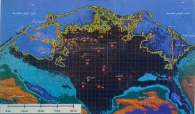
The published study forms an atlas of more than 700 colour images along with detailed topographic, geomorphologic and geographic maps of the coast and beaches of Egypt as it is today, alongside images of how the coast will look as the sea rises. It also highlights the most immediate dangers and suggests solutions to protect against the grim scenarios.
Ouda started working on the atlas in 2007, following the release of the third Intergovernmental Panel on Climate Change (IPCC) report. "My biggest problem was the lack of information on Egypt. There were no reliable maps to work on," says Ouda.
"The maps available in Egypt are a large problem for traditional researchers. The most recent updates are from 1990 and most of them are based on aerial photographs taken in the late 1960's," said Boshra Salem, chair of the Department of Environmental Sciences at the University of Alexandria, Egypt.
"We now have satellite images to work on, but prior to that extremely intensive field work was needed to go down and measure everything manually," she added.
Ouda used imagery from the Shuttle Radar Topography Mission (SRTM) from NASA, which provides high-resolution digital imagery. "We used a total of three high resolution satellites to scan the topography of the country's coasts to determine low lands that are more liable to flooding," he explains.
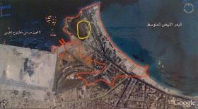
According to Ouda, Abu Qir Bay, waters stretching from Alexandria to Rosetta, is one of the most critical endangered areas. Even a small rise in sea levels would flood an important industrial area and several villages.
"The coastal morphology of Abu Qir, and all the way up to Rasheed, is not stable. It is very easy to fall if the water rises," confirmed Salem.
Exacerbating climate change, human exploitation has taken its toll on many of the lakes of the Nile Delta. Some are now at levels less than 17% of their sizes compared to 1949 maps.
Natural sand dunes act as natural barriers against the advancing waters and protect much of the Nile Delta. However, these sand dunes are constantly moving around due to winds – making them unreliable protection.
"To make it worse, I was doing some field work once and I saw workers actually scooping up the sand from the sand dunes with their equipment for construction projects," said Ouda angrily. "Little do they know that these dunes are one of the last lines of protection they have.
"We really need to reevaluate the topography we teach in schools now. The maps have changed drastically and people are unaware of the damage being cause," said Ouda.
He is hoping policymakers follow the recommendations for solutions outlined in the atlas. "I have discussed [in the atlas] the more traditional solutions, but I also show other non-traditional ones that can actually bring income to the country."
"I am very interested at the work that went into this atlas, but like any other publication, it needs to be reviewed by the different stakeholders before we take decisions based on it," added Salem.
doi:10.1038/nmiddleeast.2010.221
28 December 2025
24 December 2025
24 December 2025
Sign-up to receive our e-alert update every two weeks to keep up with everything new on the portal.
Sign up for e-alerts
Stay connected: