Using AI to control energy for indoor agriculture
30 September 2024
Published online 26 February 2011
A two-decade old development project to address some of Egypt's pressing issues — water supply and food security — was given the green-light by Egypt's interim administration. The new network of road and rail links will open up vast tracts of unpopulated desert for Egypt's growing population.
The 'development corridor', first proposed back in 1985 by Farouk El-Baz, director of the Remote Sensing Center in Boston University, promises to expand the inhabitable area of Egypt, while creating jobs for the country's large youth population.
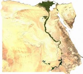
About 95% of Egyptians live around the fertile Nile River, making up less than 5% of Egypt's land. The 2000 persons per square kilometre population density is among the highest in the world. The rest of Egypt is covered by vast, sparsely populated harsh deserts, with pockets of people living at oases. "We need to open up more land for building cities and towns and to increase our potential for expansions for the younger generations," said El-Baz.
"By the year 2050, the population of Egypt will increase by 60 million people. So we need to expand the area we live in many folds, not just to double it, so that we can add more agriculture, more industry and create new potential jobs," he added.
Over several years, El-Baz and his team have used remote sensing and satellite imagery to study the landscape and geography of the Sahara Desert in detail. They have discovered large underground aquifers in Libya, Sudan and southern Egypt, such as the Nubian Sandstone Aquifer, as well as ancient underground dried-up riverbeds. Their radar images have led to the drilling of over 500 wells in the desert in an area known as Sharq Al Owaynat, allowing cultivation of hundreds of thousands of acres.
The large, mostly flat topography of the desert west of the Nile riverbed makes it the best area to develop, contends El-Baz. "We should continue developing areas like Sinai, but we need a place to move a minimum of 20 million people in the near future and that can only happen to the west of the Nile."

The project involves building a superhighway and railway network that connects the northern coast to the southern borders of Egypt, parallel to the Nile valley. There will then be 12 highways that run east to west, which will connect the main cities around the Nile to the new highway to make for easy and fast travel from the main population centres to the new areas as the new cities and towns develop.
The east to west connectors will be built first, so that they can quickly provide land for Egyptians. Once all 12 are in place, the main highway will be built to connect them all together. It will take 10 years for the whole project to be developed.
Water will be pumped from the large water reservoir in the Toshka Lakes in the south to meet the needs of people living along the new corridor. Electricity will be supplied from the main grid, but El-Baz wants to switch to solar energy in the future when it becomes more efficient.
The project will cost 23.7 billion USD, according to the financial analysis in El-Baz's proposal. "But the government does not need to pay a penny. This should be a project of the Egyptian people," he added.. "It should be open to all Egyptians through a public offering. Each one can buy shares as they can afford." Once Egyptians have bought as much as they can, he wants to open to the regional level, then finally to the international stage. He suggests raising around 40 billion USD to allow for expansion in the future.
"The return on this investment will be huge because there will be new agricultural land, new industries and large new residential centres. All this will yield good return to investors."
Since it was first announced over two decades ago, however, there have been several opponents to the project. Maghawry Diab, a geologist at Monofeya University, Egypt, said the water supply from the Toshka Lakes could never meet the needs of 20 million new residents in this area.
According to El-Baz's proposal, a 1 metre-wide pipeline from the Toshka Lakes travelling north along the project would provide enough water for the early stages of the project. Canals from the Nile River basin can provide further water as agriculture and industry develop.
Several geographers have also pointed out that the northern parts of the corridor pass through El Alamein, an area to the north of Egypt littered with landmines since World War II.
El-Baz, however, sees the project as the only way to solve the landmine problem. "When we go to the British or the Germans and ask them to remove the mines they say 'why do you care? It is only the desert'. But now we can tell them this is the cornerstone of development in Egypt." The expenses should then be divided between both countries to support the ambitious plan to develop the El Alamein area.
doi:10.1038/nmiddleeast.2011.23
30 September 2024
23 September 2024
11 September 2024
Sign-up to receive our e-alert update every two weeks to keep up with everything new on the portal.
Sign up for e-alerts
Stay connected: