Using AI to control energy for indoor agriculture
30 September 2024
Published online 21 February 2013

A team of scientists at the University of California, Irvine (UCI) went through data gathered by NASA's Gravity Recovery and Climate Experiment (GRACE) satellite mission between January 2003 and December 2009.
They estimate that there was approximately 143.6 Km3 less fresh water after the 7 years — an amount almost equivalent to the volume of the Dead Sea, publishing their findings in the journal Water Resources Research1.
"When I observed the hydrological map of the world with GRACE after the satellite was sent into orbit, the world's water 'hotspots' became obvious," says Katalyn Voss, a water policy fellow at the UC Center for Hydrological Modeling in Irvine, and the study's lead author.
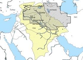
The region between the Tigris and Euphrates show a clear loss of water (see map) with two related factors to blame: a drought that struck the region in 2007 responsible for 40% of the total water loss and groundwater depletion, which accounts for 60%.
"The groundwater depletion is linked to the drought which caused a dwindling availability of surface water," says Voss, who stresses that whenever surface water levels decrease, people are forced to switch to pumping groundwater.
Andrea Cattarossi, project manager of the Strategy for Water and Land Resources of Iraq, says that water shortages due to drought in the years 2007, 2009 and 2011 meant people in the region resorted to digging more wells, and some illegal.
A World Bank report stated that the Iraqi government commissioned the digging of a thousand wells across the country in 2008 and 2009 to make up for the dwindling fresh water resources. Cattarossi says that it is difficult to estimate how many more wells were dug illegally, but suggests at least another thousand wells were dug in Iraq alone.
While Cattarossi reached the same conclusions as the UCI scientists about the major causes of the groundwater depletion, he remains skeptical about the UCI estimates. "The number identified seems very large if compared to the total amount of surface water that the entire Tigris-Euphrates River basin can generate on an average year, which is around [80-90 Km3]," he said.
James Famiglietti, a hydrologist at UCI and also involved in the study, explains that GRACE did not only focus on the outflow of the Tigris-Euphrates River basin for the year, but gave data about a much broader geographical area which includes parts of Iran, outside of the basins.
"GRACE works like a giant scale in the sky," he adds. Famiglietti's team compared the estimates of water storage changes recorded to several ground-based observational datasets and found that they match quite well.
Turkey's position upstream of the two rivers system makes it the main geopolitical player on the issue. Currently, there is still no international agreement on managing water resources in the affected region, and no system to monitor the quantity of water available or regulate the digging of new water wells.
Although the scientists are unable to predict how long it will take for the reservoirs to replenish with the data at their disposal, a World Bank report released during the UN climate change conference (COP18) in Doha in December 2012, warned that climate change will aggravate the water supply problems in the Arab world through increase droughts and decreased rainfall.
doi:10.1038/nmiddleeast.2013.26
Stay connected: