Using AI to control energy for indoor agriculture
30 September 2024
Published online 26 August 2021
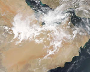
Extreme convective events that bring heavy springtime rain to the southern Arabian Peninsula appear to be growing under a warming climate.

NASA Worldview
Now, Diana Francis and co-workers at Khalifa University of Science and Technology and the National Center of Meteorology in Abu Dhabi, UAE have established a method to detect MSCs in satellite imagery, providing insights into their spatial extent, lifetime and temporal evolution. Their research reveals how certain atmospheric factors drive their formation, most notably low level winds bringing moisture from the warm seas onto the Peninsula. They also found that MCSs have been lasting longer over the past 21 years, a trend that is likely to continue in a warming world.
Collecting accurate data about MCSs is challenging because orbital satellites miss most of them. MSCs tend to last for only a few days, while an orbital satellite will visit the same region only once every 10 to 15 days.
To address this, the researchers accessed maps of infrared and visible data in a NASA product that combines multiple high resolution images of four kilometre pixels every fifteen minutes. They used radar data to detect rain, examined radiosonde profiles from weather balloons, and inferred details of the atmospheric circulation from global reanalysis data – maps of recent climate compiled using models and data assimilation.
To identify MCS events, the researchers searched for large areas of cold cloud pixels over the UAE that persisted for at least four hours, and checked whether those correlated with records of precipitation. They analysed 95 MCS events in total, and performed detailed case studies of two extreme events that happened in March 2016 and April 2019.
“We were surprised at the consistency of these spring events over more than two decades. This confirms that they are linked to the global water cycle and not to local conditions,” says Francis. “The second surprising finding is an increase in both the duration and size of the MCSs, which could actually be good news for arid countries. Urban planning in countries like the UAE should prepare for increasing floods, but at the same time try to benefit from this precious source of clean water.”
doi:10.1038/nmiddleeast.2021.74
Nelli, N. R. et al. The atmospheric controls of extreme convective events over the Southern Arabian Peninsula during the spring season. Atmos. Res. 262, 105788 (2021).
Stay connected: