Using AI to control energy for indoor agriculture
30 September 2024
Published online 5 May 2023
A regional network is building and exchanging knowledge on the measurement of water lost from farmland to the atmosphere.
Vinay Nangia, ICARDA
A regional evapotranspiration network is now filling this knowledge gap. It was recently established by the International Center for Agricultural Research in the Dry Areas (ICARDA) and the Food and Agriculture Organisation of the United Nations (FAO), in collaboration with national agricultural research institutes in Jordan, Lebanon, Egypt, Tunisia, Morocco and Palestine. The network aims to build a common regional understanding and methodology of evapotranspiration measurements, improve water resource management, and promote the development of appropriate intervention strategies to cope with water scarcity.
“The region does not have enough water resources and it’s already not food secure. With the changing climate, it doesn’t look promising. To have a good handle on your water resources is really important. But if you’re not measuring it, you cannot manage it,” says Vinay Nangia, soil, water and agronomy research team leader at ICARDA.
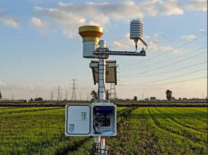
Evapotranspiration, a critical process in the hydrological cycle, is the movement of moisture from the Earth’s surface to the atmosphere by evaporation of water and transpiration from plants. The complexity of land-plant-atmosphere interactions and natural variability in topography, soil moisture and vegetation type make obtaining accurate information on evapotranspiration especially challenging — particularly in agroecosystems where water is scarce or varies seasonally, as in the MENA region.
To manage water resources effectively, accurate evapotranspiration measurements are crucial to determine water requirements for staple crops and improve crop productivity. “If you have a limited amount, you want to understand how much water is actually being lost,” says Nangia.
Before the network was established, field measurements in the MENA region were not standardised, and regional planning and policy development relied on estimates based on measurements taken outside of the region, including for crops, soils and weather, explains Nangia. “There needs to be a standard way of doing it, and the whole region has to come together. We’re trying to measure evapotranspiration and make it available to all as an international public good, and see what people can do with this information to come up with their own insights, applications and to try to benefit from this.” By making it open access, the project seeks to fill a critical information gap in the region.
Working with national agricultural research institutes, the network builds a common understanding of evapotranspiration, and methodologies for measuring it in the field and through remote sensing. The standardised data can then be used for agriculture-related applications, such as water accounting, water productivity and water management.
The project produces a representative and regionalised dataset of actual evapotranspiration measurements by including a variety of crops (such as summer or winter), conditions (such as elevation) and water applications (such as rainfed or irrigated agriculture). This data can then feed into the development of early warnings advisories and smart phone applications, for example.
“The evapotranspiration network established more focused research on crop water requirements. Actual evapotranspiration of crops has to be investigated under the current climate change circumstances,” says Ihab Jomaa, researcher and head of the irrigation and agrometeorology department at the Tal Amara Research Station in the Bekaa Valley, Lebanon. “Water resource management will greatly benefit from providing decision makers with exact crop water requirements.”
Abdallah Alimari, researcher at the National Agricultural Research Center in the West Bank, Palestine, says the regional network will be helpful in facilitating the exchange of information and data between all members. “In Palestine, evapotranspiration work is new, particularly the use of sensors and electronic devices for evapotranspiration estimates. We hope to be able to use this data to generate water requirements for crops in Palestine.”
The next phase of the project, which will commence later this year, aims to bring Yemen, Syria and Algeria on board. Fragility, access challenges or the difficulties of buying and installing certain equipment due to sanctions will make this expansion particularly challenging. “But we are trying to be representative of the region and cover as many agroecologies as possible,” says Nangia.
doi:10.1038/nmiddleeast.2023.43
30 September 2024
23 September 2024
11 September 2024
26 September 2022
23 September 2022
19 November 2021
Sign-up to receive our e-alert update every two weeks to keep up with everything new on the portal.
Sign up for e-alerts
Stay connected: