Using AI to control energy for indoor agriculture
30 September 2024
Published online 14 August 2024
Researchers studied 30,000 satellite images over six years to accurately and efficiently map litter in the Mediterranean Sea

A study in Nature Communications has shown the efficiency of using satellite images coupled with supercomputers and advanced search algorithms to routinely detect and monitor, from space, floating marine debris.
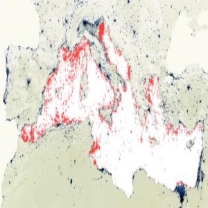
The study found that litter covers an area of 94.5 square kilometers in the Mediterranean Sea, equivalent to 7,500 football pitches after collecting data every three days between 2015 and 2021 using European Union’s Copernicus Sentinel-2 satellite.
“This task was only possible using supercomputers and advanced search algorithms,” says Andrés Cózar, a study author, from the University of Cádiz, in Spain.
Cózar adds that his team used a method that can detect patches as small as one square metre, whereas current satellites are not sensitive enough to detect patches of less than 20 m2 square meters.
The researchers of the study were able to draw the most complete marine litter map of the Mediterranean to date, indicating the most polluted areas, the major changes throughout the years, as well as the main points of entry for litter from the mainland.
For instance, Cózar explains that they identified a hotspot of floating garbage associated with the area where ships wait to transit to the Suez Canal.
The authors explain that determining the optimal sensor for monitoring marine debris is a long process that begins with knowing the radiation reflected from the various components of floating litter. The study aimed to determine the technical characteristics needed for a sensor to monitor marine debris from space, their spectral ranges, the number of satellites required, and the height or angle of observation. This is known as defining the optimal concept. The researchers exposed waste materials collected from the sea to artificial solar radiation. The resulting spectral data is then fed into a model to determine the heights the different radiations reach after passing through the atmosphere under different marine and climatic conditions where the sensor will orbit.
The second goal of the study was to use the in-orbit sensors that best matched this optimal concept to test the capabilities of the sensor.
Link to original article is here.
doi:10.1038/nmiddleeast.2024.254
Stay connected: